
Western Europe is bracing for the worst storm so far this season with hurricane-strength wind gusts and rain potentially disrupting travel and causing damage to buildings.
Storm Ciaran will bring heavy rain and intense winds from Spain to France and the UK from late Wednesday through Friday, according to according to AccuWeather. The UK Met Office issued an amber warning for southern England for Thursday as “very strong” winds could bring danger to life from flying debris, damage to power lines and canceled trains and flights.
Ciaran “will bring some very wet but also exceptionally windy weather” to the southern UK, particularly around the English Channel, said Alex Burkill, a meteorologist at the Met Office.
Scotland and Scandinavia were hit by severe weather earlier this month when storm Babet caused significant flooding and killed several people. Extreme weather events are becoming more frequent with northern nations such as the UK experiencing some of the hottest summer months on record, followed by sudden, extreme rainfall and flooding. Human-caused climate change is increasing the likelihood of such weather patterns globally, as wildfires in the Mediterranean region last summer showed.
⚠️⚠️ Amber weather warnings issued ⚠️⚠️
Very strong and damaging winds associated with #StormCiarán bringing travel disruption. Large waves may also bring coastal impacts
Thursday 0300 – 2000
Latest info 👉 https://t.co/QwDLMfRBfs
Stay #WeatherAware ⚠️ pic.twitter.com/vZ6Z0PVNoU
— Met Office (@metoffice) Oct. 31, 2023
The region could be impacted by downed trees and potential power outages, with cities including London, Paris and Brussels affected, AccuWeather said.
On Thursday, wind gusts will potentially exceed 85 miles per hour (137 kilometers per hour) in the most exposed English Channel coastal spots, the Met Office said. Rain will fall on already saturated ground in many parts of the UK after a period of wet conditions, increasing the risk of flooding, the Met Office said.
Meteo France expects Ciaran to hit western France on Wednesday evening, with gusts of as much as 150 kilometers per hour (93 miles per hour) on the shores of Brittany. Coastal areas will be at the risk of flooding amid high tides and huge waves, the forecaster said on its website.
“The extent of these high winds remains a little uncertain and is dependent on the exact track of Storm Ciaran,” the UK Met Office said. “Winds will begin to ease from the west during the afternoon. Very large waves could bring additional impacts to coastal areas, especially along the English Channel coastline.”
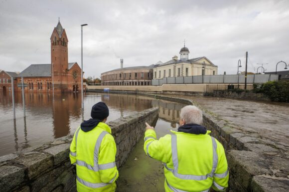
Photograph: Workers look over a flooded parking lot in Newry, Northern Ireland on Oct. 31, 2023. Photo credit: Liam McBurney/PA Images/Getty Images
Related:
Topics Catastrophe Natural Disasters Europe Windstorm Hurricane
Was this article valuable?
Here are more articles you may enjoy.
 Florida House Gives Final Approval to Much-Debated Citizens Clearinghouse Bill
  Prices for New Cars Have Soared. Here’s One Big Reason Why
  CRC Group CEO on Casualty: ‘It’s More About the Coverage’ Than Price
  Chubb to Serve as Lead US Insurer for Gulf Shipping Amid Iran War