
The state of South Dakota is working on new online flood mapping tools for the Big Sioux River Basin.
The Google maps-style program should allow cities, counties, developers and emergency managers to test the flooding potential of increased flows in the basin’s various waterways. The project is expected to be completed within three years.
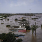
State officials say the push to create a more accurate model arose out of a failure to predict the path of a massive flood pulse in June of 2014. That resulted in the closure of a section of Interstate 29 and a railroad line to protect against flooding that didn’t overtake either transportation route, the Sioux Falls Argus Leader reported.
We knew there was going to be a lot of runoff if additional rains happened,” South Dakota Department of Environment and Natural Resources spokesman Tim Cowman said of the days leading up to the mid-June rains. “That’s exactly what did happen.”
The anticipated flooding of Interstate 29 between Vermillion and Sioux City didn’t happen, though. The models used to predict it didn’t account for the dispersing effect the Missouri River Basin would have on the surging waters as they moved south. The decision by the Corps of Engineers to reduce releases from Gavin’s Point Dam by more than two-thirds helped, too, Cowman said.
The South Dakota Legislature set aside $750,000 this year to pay a contractor to create the model. Once it’s complete, it will offer users the ability to highlight streams, move buttons with their cursor to increase flows on those streams, and to see what flooding is anticipated.
“With our model, we’ll be able to move those buttons and say `what if this happened, what if that happened,” Cowman said.
Jay Gilbertson, director of the East Dakota Water Development District, said he hopes cities and developers in particular pay attention to the information gathered through the modeling project. Dams can do only so much to protect homes, he said.
“The dams are there to control floods, not prevent them,” Gilbertson said.
Topics Flood
Was this article valuable?
Here are more articles you may enjoy.
 Portugal Deadly Floods Force Evacuations, Collapse Main Highway
  Allstate CEO Wilson Takes on Affordability Issue During Earnings Call
  Trump’s Repeal of Climate Rule Opens a ‘New Front’ for Litigation
  AIG’s Zaffino: Outcomes From AI Use Went From ‘Aspirational’ to ‘Beyond Expectations’