
Potential storm surge impacts in the Tampa Bay region based on different factors associated with storms have been mathematically modeled by two University of South Florida College of Marine Science physical oceanographers.
USF College of Marine Science physical oceanographer Robert Weisberg and his associate Lianyuan Zheng used data collected by the National Oceanic and Atmospheric Administration, the U.S. Geological Survey and other agencies during last season’s batch of hurricanes to predict the surge rates and show how the water level in Tampa Bay changes.
“What we’ve attempted to do is model the potential for surge in this region based upon many different factors associated with the storm,” Weisberg told the University of South Florida Oracle.
In comparison to how the media currently models and predicts storm surge, “(Weisberg) has models that provide much more accurate information about what might happen during a storm,” Al Hine, a College of Marine Science associate dean for research said.
Weisberg gave an example. “We often get reports in the media that a category-two storm will give a storm surge of a certain amount, and that’s not really true,” Weisberg explained.
“Weisberg can show specific areas that might flood worse than others,” Heine said. “People say a certain-sized storm is going to come and the storm surge is going to be 10 feet. Well, it’s not 10 feet everywhere. It might be two feet somewhere and 14 feet somewhere else. He can show what specific sections of coast and Tampa Bay are going to really get slammed and what parts won’t.”
According to Weisberg’s findings, storm surge in Tampa Bay could potentially be disastrous. “If we had a Category 4 storm that makes landfall just north of Tampa Bay and is moving kind of slow, we could see surges that, in my model results, are at some six meters or so, which is around 20 feet.”
Weisberg pointed out some of the places that are more vulnerable to storm surge in the Tampa Bay area. “All of the low-lying areas are at risk. The worst flooding is normally in the northern reaches of the bay. So up toward Tampa and around Safety Harbor, that’s where we tend to get the worst flooding.”
Hine pointed out how application of Weisberg’s storm surge model might help in preparation for a hurricane. “Knowledge is preparation, forewarned is forearmed, so if you know more you’re better off. He can predict what certain areas might be more heavily impacted than others and it provides a level of sophistication that, heretofore, has not been available.”
In regard to storm preparedness, Weisberg said his model “provides additional guidance in planning for evacuations.”
Topics Windstorm Education Universities
Was this article valuable?
Here are more articles you may enjoy.
 Insurance Issue Leaves Some Players Off World Baseball Classic Rosters
  A 10-Year Wait for Autonomous Vehicles to Impact Insurers, Says Fitch
 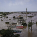 Portugal Deadly Floods Force Evacuations, Collapse Main Highway