
Tropical Storm Nicole was over west central Florida to the northeast of Tampa at 10 a.m., having weakened from being a Category 1 hurricane when it made landfall earlier in the morning on the coast.
Nicole’s maximum winds have decreased to near 52 mph with higher gusts, according to the National Weather Service.
The current forecast calls for additional weakening while Nicole moves over land during the next day or two, and the storm is likely to become a tropical depression over Georgia tonight or early Friday. Nicole is expected to reach the Mid-Atlantic by Friday night.
Gov. Ron DeSantis today expanded the state of emergency to all of the states 67 counties due to Nicole. President Joe Biden approved an emergency declaration for Florida and ordered federal assistance to supplement state and local response efforts.
Evacuations were ordered from barrier islands in Flagler, Palm Beach and Volusia counties. Orlando International Airport remained closed this morning, while Palm Beach International Airport announced it would resume operations at 8 a.m.
At a press briefing, Gov. DeSantis said there have been reports of downed trees and power lines, along with some road washout.
Duke Energy reported that about 100,000 customers statewide have lost power.
In accordance with the statewide emergency order, on Thursday Insurance Commissioner David Altmaier exercised his authority to order that insurers may not cancel or nonrenew any personal residential or commercial residential property insurance policy covering property damaged as a result of Hurricane Ian or Nicole for a period of 90 days after the dwelling has been repaired.
The state’s property insurer Citizens has suspended all policy binding due to the storm. Agents may not bind applications for new coverage or policy changes for increased coverage, regardless of effective date, when a tropical storm or hurricane watch or warning has been issued.
Nicole remains a large tropical storm. Tropical-storm-force winds extend outward up to 345 miles from the center, especially to the northeast. Saint Augustine, Florida, reported average winds of 52 mph and a wind gust of 70 mph.
Tropical storm conditions will continue along the east coast of Florida, Georgia, and South Carolina within the warning areas today. Tropical storm conditions will spread northward along the west coast of Florida to the coast of the Florida Panhandle through tonight.
A dangerous storm surge is expected along portions of the east-central and northeastern coast of Florida, portions of coastal Georgia, and the Florida Big Bend along the Gulf coast.
Nicole is expected to produce heavy rainfall, through Saturday, with 3 to 5 inches in Florida and 2 to 4 inches in the central Appalachians and eastern portions of Tennessee, Kentucky, and Ohio. Flash and urban flooding will be possible along the St. Johns River, across the Florida Peninsula today.
A few tornadoes were possible this morning over parts of coastal east-central and northeastern Florida. The tornado threat will spread northward across parts of southeastern Georgia and the Carolinas later today through Friday morning.
The storm is hitting as the region continues to recover from larger and more intense Hurricane Ian.
Federal aid to Florida for recovery from Hurricane Ian has topped the $2 billion mark, according to the Biden administration. Most of the money was provided by the Federal Emergency Management Agency. About $710 million went directly to households, and another $322 million went to the state. The Small Business Administration furnished $631 million in disaster loans, and the National Flood Insurance Program has paid out $351 million in claims.
Was this article valuable?
Here are more articles you may enjoy.
 ‘Structural Shift’ Occurring in California Surplus Lines
  A 10-Year Wait for Autonomous Vehicles to Impact Insurers, Says Fitch
  How One Fla. Insurance Agent Allegedly Used Another’s License to Swipe Commissions
 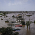 Portugal Deadly Floods Force Evacuations, Collapse Main Highway