
As high temperatures break records around the US and wildfires rip through the West, another climate-driven weather hazard — extreme rainfall — is pummeling the country’s Northeast and scientists say it will get worse as the climate changes. That will bring more rain-induced flooding to a region of millions that isn’t prepared.
The latest example played out on Aug. 18, when a slow-moving storm system approached Northeastern states from the Great Lakes. A patch of low pressure high above Connecticut and New York drew all that wet air upwards, creating perfect conditions for rain. Remnants of Hurricane Ernesto also arrived, slowing down the movement of air masses across the region into a kind of “traffic jam,” according to AccuWeather Inc.
“The situation itself wasn’t all that unusual,” said Tom Kines, a senior meteorologist at AccuWeather. “It just happened to be the kind of the worst-case scenario where you get heavy thunderstorms over one area for an extended period of time.”
The outcome was anything but usual. Within 12 hours, the area saw two 1,000-year rainfalls — events that have a 0.1% annual chance of occurring — only 35 miles apart.
“Some areas picked up two or three months’ worth of rain,” Kines said.
Particularly hard hit were southwestern Connecticut and north-central Long Island, where rain fell at a rate of 3.5 inches an hour in some places. In Connecticut, two people died and more than 100 needed rescue.
Two rainfall stations in Oxford, Connecticut, showed 24-hour totals of 14.83 inches (37.67 centimeters) and 13.5 inches. A committee is evaluating the measurements, which if validated would surpass the existing state record of 12.77 inches, set Aug. 19, 1955, during Hurricane Diane.
Parts of Long Island saw flash flooding from more than 9 inches of rain, and Northern New Jersey was drenched at lower volumes.
The storms drew fuel from an environment dramatically changed from when record-keeping began in the area, in the late 19th century. The whole world is on average 1.3C hotter. For every 1C rise, air can hold up to 7% more water.
The intensification of extreme precipitation has been rising in line with this basic relationship between heat, air and water. It’s why, when the right conditions line up, there’s often more rain to fall than in decades past.
“As water vapor goes up, heavy precipitation goes up,” said climate scientist David Easterling, chief of the Climate Assessments Section at the US National Oceanic and Atmospheric Administration.
And it’s doing so in the Northeast faster than in any other part of the US, according to the Fifth National Climate Assessment, published last year. Precipitation is higher year-round, and the worst of it has jumped 60% over six decades. The most recent United Nations climate report noted a marked rise in extreme precipitation in North America, amid a greater frequency and magnitude globally.
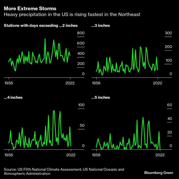
The most extreme precipitation in the Northeast is seeing the fastest growth. Days with more than 5 inches rose 103%. Most of it is coming during warm seasons, sometimes as cyclones or bad weather left over from them, rather than snow, which parts of the region are seeing less and less of.
And these charts show only concentrated, short-term events. “We also need to be looking at multiple-day events, where different types of storm systems lead to rain or precipitation falling almost consistently over two to three days,” said Lesley-Ann Dupigny-Giroux, Vermont’s state climatologist.
Ways to protect people are not keeping up with this rate of change. Vermont alone has seen devastating flash flooding, both this summer and last — despite advanced flood preparations undertaken after the catastrophic Hurricane Irene in 2011.
Thunderstorm-related damage from wind or hail has seen “a very notable uptick” in recent years, said Steve Bowen, chief science officer at Gallagher Re. Flood events are more likely to fluctuate based on which phase the Pacific Ocean is in — El Niño, La Niña or neutral.
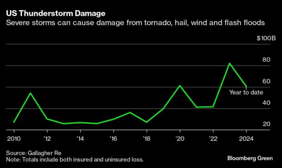
Read More: Giant Hail Is the Weather Threat Keeping Insurers Up at Night
Almost all flood insurance in the US is provided by the government’s National Flood Insurance Program, yet it covers only 12% to 14% of annual flood damage. From 1978 to 2015, New Jersey and New York received more payouts than all but two other states. Yet region-wide, Northeast coastal counties see only about 6.5% takeup of flood insurance, and inland counties, which are at greater risk of flash flooding than ever, have a 1.5% rate.
That means one of the most dangerous symptoms of climate change is coming for a highly developed (read: paved) region, where people who live outside of nationally designated zones face no mandate to buy flood insurance and generally don’t.
Insurance is how individuals protect themselves. Planning and engineering are how communities do it, and they currently have insufficient tools: The US precipitation frequency estimates used for planning, called Atlas 14, are based on historical data and came together over time in piecemeal fashion. Engineers need up-to-date future rainfall estimates to know what specifications to build to.
Read More: The Risky Business of Predicting Where Climate Disaster Will Hit
The US is working on its ability to estimate what’s coming. The 2021 Bipartisan Infrastructure Law for the first time authorized spending to update the Atlas project for climate change, and to estimate precipitation frequency everywhere in the US. Atlas 15 is expected to be completed by 2027.
Even so, the Department of Defense didn’t want to wait. For a project the Pentagon funded, Easterling and colleagues built an online tool that displays the Atlas 14 results and then 10-year projections from 2025 to 2085. Two military installations about 70 miles east and west of Oxford, Connecticut, where last week’s storm unleashed the most rain, may each see high-end rainfall rise by an inch or more by 2045.
Cyrena Arnold is director of product marketing for weather and climate data provider Atmospheric G2. A meteorologist and storm chaser, she also makes explanatory videos on TikTok, including an analysis of the recent Connecticut-centered storm.
“People are saying, ‘Oh my gosh, we’ve never seen this type of weather before. We’ve never had this before,'” said Arnold, who lives in New Hampshire. She often tells them that New England’s weather today is what used to be normal weather a few degrees of latitude to the south: “This is what used to happen down there, 20 to 30 years ago. And it’s now happening up here.”
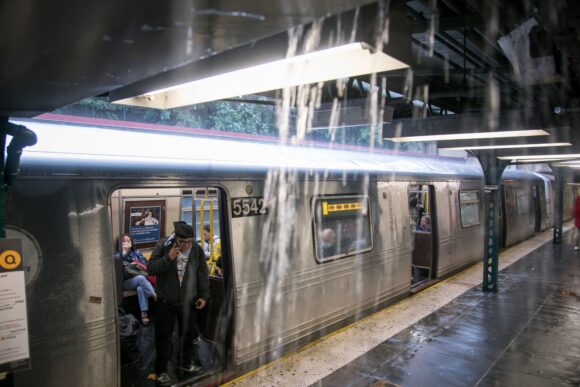
Photo: Bloomberg file
Topics USA
Was this article valuable?
Here are more articles you may enjoy.
 US Appeals Court Rejects Challenge to Trump’s Efforts to Ban DEI
  Portugal Deadly Floods Force Evacuations, Collapse Main Highway
  Allstate CEO Wilson Takes on Affordability Issue During Earnings Call