
A multi-day severe weather outbreak is expected to bring heavy thunderstorms, large hail and the threat of tornadoes across the central U.S.
Parts of the Upper Midwest – particularly southern and western Minnesota and northern Iowa – is at highest risk for severe weather, the National Weather Service said. The NWS’s public severe weather outlook warns of intense tornadoes, scattered large hail and scattered damaging winds.
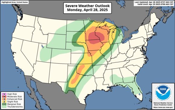
Monday could be one of the most active days of severe weather so far this season, according to AccuWeather expert meteorologists, who warn that a fast-moving jet stream could create conditions for intense tornadoes for parts of the Midwest. The worst of the storm is expected to hit the Upper Midwest Monday afternoon into Monday night.
“Not only will these thunderstorms be capable of producing tornadoes, but also large hail and widespread damaging winds from Minnesota and Wisconsin through Iowa and northern Missouri,” said AccuWeather Meteorologist Alexander Duffus.
The Upper Midwest typically sees their highest risk of tornado activity in May and June, according to AccuWeather Severe Weather Expert Guy Pearson.
“This is not considered the normal time of year for major tornado threats in the Upper Midwest, but all of the ingredients needed for tornadoes are in place today. Everyone needs to take this severe weather threat seriously.”
The risk of severe thunderstorms will shift eastward Tuesday, AccuWeather said, spanning from northern Texas into New York, New England and southern Ontario. The weather agency said that the risk of severe thunderstorms across western and northern Texas, as well as much of Oklahoma, will arrive Tuesday evening.
A slow-moving front is forecast to bring repeated rounds of thunderstorms to the Plains and Ohio Valley this week. Oklahoma to western Missouri and Arkansas face the greatest concern for flash flooding, AccuWeather said.
Topics Catastrophe USA Natural Disasters Windstorm
Was this article valuable?
Here are more articles you may enjoy.
 Florida’s Commercial Clearinghouse Bill Stirring Up Concerns for Brokers, Regulators
  A 10-Year Wait for Autonomous Vehicles to Impact Insurers, Says Fitch
  Insurance Broker Stocks Sink as AI App Sparks Disruption Fears
  AIG Underwriting Income Up 48% in Q4 on North America Commercial